Thursday, February 19, 2009

Dhauladhar range, where red and orange robes of the Lama mingles with the white of these mountains.


Himachal Himalayas
District Kangra & Chamba

Dhauladhar range

Kangra presents an expansive front along the southern foothills of the Dhauladhar range. With only the modest Shivaliks below, Kangra has always give easy access to the monsoons, as well as number of invaders. The rains endowed its temperate lands with rich harvests, and the state became renowned for its prosperity.

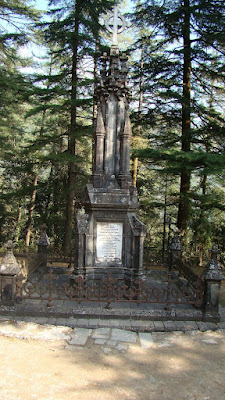
Lord Elgin Church, Macloedgunj. Dharamsala

Jwalamukhi temple, Kangra valley

Deeply religious, the people of Kangra donated generously to the numerous shrines that dotted the countryside. Some temples, like the Brajeshwari Devi temple in Kangra town, had accumulated legendary wealth, and became the irresistible targets of raids from the Turkish sultans.

Kangra fort

Mohammed of Ghazni carted off a fortune in gold, silver and jewels in AD 1009, and the shrines were plundered again in the 14th century by Tughlaqus. Each time the devotion of people proved greater than the rapacity of the raiders, and the shrines invariably recovered in stature. Eventually, under the tolerant reign of Akbar and later Maharaja Rnajit Singh, the shrines were given royal protection, and have since become milestones in the history of an ever strengthening faith.
Today, Kangra’s rain drenched vistas of lush terraces, chain of fruit orchards, and cluster of roof bright with drying corn and red pepper are as inviting to a visitor as they were to the eyes of Turks a thousand years ago.

Buddhist monks at Macleodgunj, learning the sounds....

It is not surprising that the Dalai Lama opted to make this land his home-in-exile. In the town of Dharamsala, the strong Tibetan influence is now an added attraction to the tea gardens that carpet the surrounding slopes. Kangar’s chequered history of the conquests and recovery ensured that it acted as a buffer between Chamba and change. While Kangra suffered strife, continuously experiencing different rulers, Chamba - across the Dhauladhar - remained physically untouched because it formally acceded to whoever controlled Kangra. This insulation ensured an unbroken tradition of medieval Hinduism in the district, symbols of which are still in evidence today.

Sunday, January 18, 2009

Glaciers and prominent peaks of Himachal Pradesh

GLACIERS IN HIMACHAL PRADESH


Himalayas have nearly 15,000 glaciers and it is one of the largest continental areas under ice. It is estimated that about 34,000 sq. km., about 18 % of the Himalayas is always covered with ice. An average Himalayan glacier has the capacity of nearly an 11th of a cubic km. But to form a large dam, even a medium glacier can provide enough water. And large glaciers like Gangotri can even fill dams like Bhakhra dam the three times.
But there is not much known about the Himalayan glaciers. There is a very little information about the exact volume of water that is received by the Indian rivers in the form of rain, underground water, snow and water from the melting of glaciers. Generally glaciers start melting in the monsoon season. So this system provides water to those areas or rivers where monsoon is weak, thus maintain the balance very well. This system also provides many rivers a tremendous boost in water level in monsoon season and causes floods. Glaciers are called 'Shigri' in local language. Some of the important glaciers are as under.

Bara Shigri

Bara Shigri is the largest glacier in Himachal Pradesh. It is located in the Chandra valley of Lahaul and it feeds the river Chenab. Bada Shigri glacier is more than 25 km. long and about 3 km. wide. It lies on the middle slopes of the main Himalayan range. It is also aided by many small tributary glaciers. It is surrounded by high mountains from three sides. It is said that this glacier formed Chandertal lake by causing a major havoc in Chadra valley in 1936. Bada Shigri glacier was conquered by all women mountaineers in 1956. It was further successfully trekked by Stephenson in 1956. There are number of prominent glaciers in Chandra valley in Lahaul. Some of them are Chhota Shigri ( means Small Glacier ), Kulti, Shpting, Pacha, Ding Karmo, Tapn, Gyephang, Bolunag, Shili and Shamundri. Gyephang is the chief deity of Lahaul valley and the Gyephang glacier is named after him. It is full of snow all the year. It is considered as the Manimahesh of Lahaul.


Chandra Nahan Glacier


It is located on the South-Eastern slopes of the main Himalaya in the area to the North-West of Rohru in Himachal Pradesh. Chandra Nahan Glacier is also aided by various small tributary glaciers. The famous Chandra Nahan lake lies in it and it feeds the river Pabbar. Chandra Nahan lake is accessible only to experienced trekkers and fed by a series of springs. Chandra Nahan glacier is surrounded by high rising peaks. The elevation of Chandra Nahan glacier is more than 6,000 meters.

Bhadal Glacier


Bhadal glacier is located on the South-Western slopes of the Pir Panjal range in the Bara Banghal area of Kangra district. It feeds the river Bhadal. Bhadal river rises from the snowy range of the area lying between the Pir Panjal and Dhauladhar ranges. Bhadal river's catchment is made up of U shaped valleys, waterfalls, moraines, cirques and towering peaks. This river is one of the main tributaries of the river Ravi. The size of Bhadal glacier suddenly grows up because of rapid and heavy snowfall.
Bhaga Glacier:- It is located on the slopes of the main Himalayan range in Lahaul area. This glacier feeds the river Bhaga. U shaped valleys, waterfalls, glaciers and moraines characterizes the upper catchments of the Bhaga river. The entire tract is devoid of a vegetative cover. The discharge of this river increases during the summer months, when the snow on the high mountains start melting. Bhaga Glacier is surrounded by high snow-clad peaks from all sides. Bhaga glacier is 25 km. long. The other important glaciers of Bhaga valley are Lady of Keylong, Mukkila, Milang and Gangstang.

The Lady of Keylong


The Lady of Keylong glacier is very popular among visitors. The name 'Lady of Keylong' was given by 'Lady Elashainghday' about a century ago during British ruling. The glacier is situated at an altitude of about 6,061 meters and it can be seen clearly from Keylong. It remains covered with snow throughout the year. But in the middle, there is seen a dark bare patch that looks like the figure of a womam, walking with a load on her back. It is also recorded as 'Lady of Keylong' by the geological survey team of India.

Other Glaciers

Mukkila Glacier


It is situated at the height of about 6,478 meters. It is located in Bhaga valley. Its impression is awesome.


Sonapani
It was first surveyed by Walker and Pascoe in 1906. It is visible from the Rohtang Pass. It is about 6 km. from the confluence of Kulti Nala.


Gora Glacier
It has receded in the recent past due to a unstable mass balance. It lies in the South facing slopes of the main Himalayan range.


Perad Glacier


The Perad glacier is small and easily accessible and it is near Putiruni. It also has a nice cave.


Parbati and Dudhon
These glaciers are located in district Kullu. Both glaciers are 15 km. long. They feed the Parbati river.


Beas Kund
It feeds the river Beas and is located on the South facing slopes of the towering Pir Panjal near the world famous Rohtang Pass.


FAMOUS PEAKS IN HIMACHAL PRADESH


1. Shilla 7,025 Kinnaur
2. Leo Pargial 6,791 Kinnaur
3. Shipki 6,068 Kinnaur
4. Manerang 6,597 Spiti
5. Mulkila 6,520 Lahaul - Spiti
6. Kinner Kailash 6,500 Kinnaur
7. Jorkaden 6,473 Kinnaur
8. Dibibokri 6,400 Kullu

Pyramid
9. Gyephang 6,400 Lahaul - Spiti
10. Phawarang 6,350 Kinnaur
11. Shigrila 6,230 Lahaul - Spiti
12. Indrasan 6,220 Kullu - Manali
13. Shikhar Beh 6,200 Lahaul - Spiti

14. Mukar Beh 6,070 Lahaul - Spiti

15. Gepang Goh 6,050 Lahaul - Spiti

16. Deo Tibba 6,001 Kullu

17. Solang 5,975 Kullu

18. Pir Panjal 5,972 Chamba

19. Maiwa 5,944 Kullu

Kandinoo

20. Hanuman 5,860 Kullu - Kangra

Tibba
21. Bara Kanda 5,860 Bharmaur

(Chamba)
22. Pishu 5,672 Kinnaur
23. Kailash 5,660 Bharmaur

( Chamba )
24. Saltu-Da-Par 5,650 Lahaul - Spiti
25. Gushu 5,607 Kinnaur
26. Raldang 5,499 Kinnaur
27. Shitindhar 5,290 Kullu
28. Srikhanda 5,182 Kullu
29. Thamsar 5,080 Chamba
30. Lachalunga 5,060 Lahaul - Spiti
31. Murangla 5,060 Lahaul - Spiti
32. Shringla 4,999 Lahaul - Spiti
33. Inder Kila 4,940 Kullu
34. Pin Parbati 4,800 Kullu

Tuesday, December 30, 2008

Geographical distribution of flora and fauna in Himalayas

Geographical distribution of flora and fauna in Himalayas
The transition zones from sub-tropical warmth to artic colds are telescoped into a mere 250kilometers (156 miles) between the Punjab plains and the Tibetan plateau, Himachal Pradesh is an ideal habitat for a rich species of flora and fauna.
The heritage toy train meandring up through the lesser Himalayas into Shimla hills.

Towards the plains, the Shivalks are fringed with broad-leaved Sal and silk cotton, which give way to sheesham, kail and the long leaved cheer pine on the slopes of the foothills. A temperate zone of the mixed forests follows on the lower reaches of the Dhauladhars and Pir Panjal ranges, which are covered with mossy oak, dropping branches of Spruce, and the smooth silvery bark of the West Himalayan fir. Near streams or on the colder northern slopes one finds the maple, but most significant is the tree of the gods and the pride of the Western Himalaya –the stately deodar. This magnificent conifer soars up to a height of 45 meters (150 feet).


Into the Himalayas among the tree of Gods, Himalayan Cedar
The neat park-like coniferous forests begin to thin around 2,700meters (9,000 feet). Windblown birches and clumps of stunted junipers mark the tree line, beyond which extend the idyllic alpine meadows. Here in summer, a profusion of wild flowers, including the rare Himalayan blue poppy, push out their way out of the thawing soil.
These varying life zones support an exciting range of fauna. One of the lasting pleasures of a walks in these woods are the alluring calls from unsighted birds. Easily traced are the whistling thrushes, magpies, tits and woodpeckers. Flycatchers pirouette in mid air to claim their catch, while nuthatches and tree creepers comb the fissures in the bark of conifers. The sudden flight of the Koklas and Khalij pheasants from the undergrowth never fails to startle, and if one has the patience of the Himalayan pied Kingfisher, one can be rewarded by the breathtaking sight of a bird in nine iridescent colors –the Monal. At higher altitudes, the bird life begins to thin along with the trees. Rarer the numbers, but clearly visible when present, are the snow cock, the Himalayan choughs, rose finches and accentors. Overhead, gliding in the thermals, one is likely to spot the griffon vulture, perhaps the lammergeyer with its beard and nine-foot wingspan, and if one is lucky, the golden eagle. The sight of a skein of wild geese on their migratory flight, flights the wind at 6,000 meters (20,000 feet), is an unforgettable experience.

Himalayan Pied Woodpecker
Mammals are not easily sighted. Encroachment on the forest cover by the human population has forced them to retreat into the protected zones, where their natural habitat is still preserved. In Himachal Pradesh, 28 such areas have been demarked as sanctuaries. In most cases, these are the sparsely populated higher reaches of the valley and of the valleys and the passes that have served as an avenue for the movement of wildlife across the ranges. They present a unique enclave, in which Eurasian and tropical species comes into contact. Perhaps the most beautiful animal, and certainly the most exclusive, is the fabled snow leopard. It has an attractive spotted pelt of smoky gray, paling to pure white on the underside, which is prized by poachers who have, thus sadly, enhanced its rarity. Its prey is more easily sighted by trekkers: Bharal and Goral graze on open slopes, while the Ibex easily identified by its large scimitar horns and characteristic beard, may present a striking silhouette at the edge of a steep stiff. Another attractive goat partial to steep terrain is the Himalayan Thar, with its unmistakable shaggy straw-colored shoulder ruffs. Solitary in their movement are the more reticent musk deer, which shares the insecurity of the snow leopard, since they too are sought by poachers who have thus, sadly, enhanced its rarity. Its prey are more easily sighted by trekkers: Bharal and Goral graze on open slopes, while the Ibex, easily identified by its large scimitar horns and characteristic beard, may present a striking silhouette at the edge of the steep stiff. Another attractive goat partial to the steep terrain is the Himalayan Thar, with its unmistakable shaggy straw-colored shoulder ruffs. Solitary in their movements are the more recent musk deer, which share the insecurity of the snow leopard, since they too are sought by poachers for their precious musk glands. More widely distributed are the barking deer, the Himalayan Brown and Black Bear, the forest leopard, the fox and of course the macaques and langurs. The most satisfying way to observe this wildlife is by trekking in these magnificent areas.

The snow leopard

Saturday, December 27, 2008

The valleys of delicious apples in Himacahal Pradesh


A full day drive to Thanedar


Hidden away in the Shimla hills, Kotgarh is famous for its apple orchards but very few knows about the inspiring feature that makes an excellent spring-summer destination.
Close to Narkanda, the hill range known as Kotgarh is just 16 kilometers from National highway that heads into the valley through Kumarsain, Rampur and Kinnaur and towards the Indo-Tibetan border. A branching spur breaking out from the Hatu peak Range that is splited by the fault line carved by the Satluj river, deep in the valley, makes up for what is known as the Kotgarh region.
Hatu peak can be accessed by a narrow motorable road from Narkanda that is functional during the summer months. Alternatively, the 8 kilometer of trek through dense pine, spruce and oak forests are a better option for reaching the mountain top that also mark the tree line of the Himalayan terrain. The view from Hatu Peak is breathtaking. Besides the perennially snow capped chain of the greater Himalayan ranges, very few peaks in the vicinity match the grandeur on display from here. The rarified air and the clouds gliding by, give Hatu peak a surrealistic setting. In early May, hundred of people from near and far villages trek it to the mountain top to savor of a spring fair held at Hatu.
Pre-dating the advent of British settlers in the early part of the 19th century, Kotgarh was overrun by Gorkha warriors. These hardy warriors are said to have established a fort on Hatu peak to maintain suzerainty over the surrounding territory which they held by force. Today, no traces of the fort can be seen as nature has reclaimed the remnants.
An 8 kilometer drive from Narkanda on the road to Thanedhar takes you to a ridge-top lake, popularly known as Tani jubbar, ‘a meadow within a Lake.’ This is a tranquil point, offering solace. A temple in a pahari architectural style sanctifies the lake as a holy one. The enclosing deodar forest keeps the spot shaded and hidden away. Trans-continental migratory birds sometimes do spot the water body and there have been some occasions when some of them have rested by a week or more during the winters.
On the last day of May, a spring festival held at Tani jubbar and this is a good occasion to witness local celebration and gaiety. The local deity, carried in a palanquin, with believers dancing to drum beats is integral to this local fair held amidst scenic settings.
Further on the road beyond Tani jubbar is Thanedhar which used to be the market centre of Kotgarh till it burnt down in the mid 1970’s. Long before this, during British rule, it was a major transition station for those heading into or out of Tibet.
‘Barubag’ is the ridge top at Thanedhar. This was where the American Quaker missionary, Samuel Evans Stokes chose to settle down. He bought the property from an English lady, married a local girl, converted to Hinduism and built Harmony Hall, the name he gave to the house that still stands on the spot. At a little distance from his house, Stokes built a temple, which perhaps is one of its own kinds in the whole of north India. The Gita Temple that Stokes built does not have ant idol protected in its sancto-sanctorum. In place of this, there is a sacred fire place (Havan Kund), where amidst the chanting of mantras, a sacred fire was lit where Stokes attended the ceremony religiously every morning.
The temple and Harmony Hall still mark the presence of the man who introduced commercial growing of apples to the hills. In less than a hundred years, apple as a cash crop has become so successful that it gives a livelihood to over a million people and churn up an economy of Rs 1,500 crore, each year. A summer fair held in mid-June ia a good time to be around Thanedhar.
Other than the Hatu peak, Tani jubbar and Barubag there is the locality of Kotgarh village, lower down in the hills, from where the whole area derives its name.
About two hundred years ago, the first British soldiers who came to fight the Gurkha occupation in the hills, converted Kotgarh village into cantonment. Locally the place till date is known as Chavani (cantonment). Church ta Kotgarh
Like every civilization, the invading soldiers carried their religion and gods along. So A church was established and this 1841 structure is still exist. Near Kotgarh village is the village of Melan, where temple dedicated to Chattar Mukh, the presiding deity of Kotgarh is housed.
Apples have substantially changed life patterns and made life in the hills sustainable. Prior to introduction of this cash crop, it was the fertile irrigated fields on the bank of the river satluj, deep in the valley, that provided the bread and butter for the most of residents. The higher altitudes provide only malginal crops and were used as grazing lands for sheep and cattle in the summer months. A trek or a drive into the valley provides glimpses of variant crop patterns thriving in temperate to tropical climatic zones. Famous for not having introduced commercial growing of fruits into the hills, the unique dress that the Kotgarh women wears ‘raista’, a full length skirt like garment with a attached blouse which has become trademark of Himachali women.

Friday, December 26, 2008


History of water supply for Shimla
The history of the water supply in Simla is extremely interesting, firstly, because it relates to great engineering feats, and secondly, because water vitally concern the health and existence of the population of the town. Roughly speaking the water supply has cost to the date about 54 lakh rupees. Prior to 1880 Simla depended partly on local ‘baolies’ (springs), and partly on the reservoir fed by the water issuing from two tunnels bored a short distance into Jakhoo on either side of the Combermere bridge ravine.
In 1880 the first serious attempt was made to tackle the water problem, when some 15,000 acres of land was accuired on the south of Mahasu ridge from the Rana of Koti. This was the beginning of the now extensive Catchment area, and a 6" pipeline eleven miles in length was laid to deliver water in the new reservoirs at the church and Sanjoli and this pipe gave and still give, a discharge of 60,000 gallons per day during the hot weather.
In 1893 the catchment area was extended to the old toll-bar on the Mashobra road, and two stem engines were installed at Cherot Nullah, 1,300 feet below the Hindustan Tibet road and the supply increased about 150,000 gallons daily.
This again proved insufficient, so in 1899 a second gravitation pipe line, four miles in length, was constructed to tap at the lower level the same stream as the pipe laid in 1880.
This added 150,000 gallons daily to the supply available for the pumping at Cherot where a third stem pumping engine was installed, and a large storage reservoir holding 2 and a half million gallons was built at Seog in the Catchment area forest.
Then came the railway and increasing requirements in connection with the new sewage works and the demand again rose above the supply, and 1913 saw the installation under the able direction of Captain B.C. Battye R.E.L., of the Chaba electricity generation station on the Sutlej and the Chair pumping station on the ravine below Fagu and Shali peak.
The capacity of Chair station is 300,000 gallons lifted by ram pumps driven by the electric motors to a height of 3,000 feet, to the tank above Hindustan-Tibet road about 9 miles from Shimla. From this tank the water run by gravitation in 6" and 7" mains via Kufri and Charabra. Into the Catchment area to Dhali, and there the whole of the water from the Chair, Cherot and the Catchment area is filtered in slow sand filters and then goes on in 3 pipes of various sizes to Sanjouli.
In 1941 advantage was taken of the electricity to install at Cherot a turbine pump driven by an electric motor, and from this date it was possible to dispense with the services of number of wood cutters and coolies who had hitherto provided fuel for the boilers working the steam pumps. The presence of this large body of workmen in the Catchment area had always been objected to by the sanitary authorities.
It was then hoped that the Chair extension would suffice for the needs of the station for some years, but the new generation arose which demanded considerably more comfort and convenience.
Visitors at hotels clamored for English baths and sanitation, Government offices were no longer satisfied with primitive sanitary methods, and the owners and the tenants of the houses who had previously been content with the one tap in the compound, wanted water laid on to the bathrooms, kitchens and pantry. In additions to these demands the Municipal Committee encouraged the builders of the new houses to install sanitary fittings, and commenced replacing obsolete Municipal latrines with those of the modern type.
However, in 1919 a definite scheme was placed before the local government for pumping from the Guma on the Nauti River 4,000 feet below Mashobra.
In 1920 Mr. A.F. Henderson was placed on special duty to prepare the Guma Pumping Project in detail, and was sanctioned in 1922, and completed at the end of 1924. at Guma there are two electricity driven ram pumps, each capable of lifting 35,000 gallon per hour, to the reservoir on the ‘Craignanao’ estate, now the property of the United Service Club, at the height of 4,000 feet above Guma. This lift is reputed to be the highest for water works purposes in the world, and the pressure on the pumps there is over quarter of a ton per square inch. The rising mains are of steel, varying in thickness from an half an inch at Guma to quarter inch at Craignano. At Guma the water passes through settling tanks and then after treatment with alum to coagulating tanks and finally to Paterson filters, but as a second safeguard the water is treated at ‘Craignano’ an 18-inch main leads to the reservoir at Mashobra and thence a 12-inch main takes the water to Sanjouli reservoir.
From this brief description it will be gathered that the Guma scheme is unique in the history of waterworks undertakings, and after he has designed it the execution was also entrusted to Mr. Henderson who was assisted by Mr. Main.
The distribution system in Shimla is intricate, for not only the pressure in the mains be reduced at intervals, but arrangements also exists through which pressure may be augmented in case of fire, and the whole system is controlled by an elaborate system of recording meters and valves in order that leakage may be readily detected. All houses connections are metered, and probably Shimla is the only town in India, where this wise policy has been consistently pursued by the Municipal Committee.