Showing posts with label Enchanting Himalayas.. Show all posts

Sunday, August 8, 2010

Himalayan flora


Himalayan wild flowers in monsoons

Himalayas are full of life; they have been a temptation to travelers from all around the
globe to cherish their profound beauty. Monsoon in Himalayas is a dream for nature
lover, mountains and valleys wrapped under a thick veil of fog, being constantly waved
by cool breeze unveils the hidden beauty under it. The Himalayan flora have always kept
the world inquisitive, the thick green coniferous cover loaded with moist moss, every tree
narrates a different story. Forests, meadows, riversides and even craggy cliffs are adored
with diverse flora.
 
The foothills of north Indian Himalayas sets a carpet, for this symposium with nature.
A photo presentation of these introverted and charming wild flowers discovers our
relationship with them.


Dutch clover

Columbine

African blue Lilly

Wild geranium

Wild strawberry flower

Wild strawberry

Himalayan raspberry


Monday, May 31, 2010

The tree of Gods

As The Himalayas derives their name as ‘The abode of snow’ so does the Himalayan Cedar. Right from mythological saga, to scientific feat, ‘Devdar’, ‘The tree of Gods’ stands high as its name. So the tree shares a deep rooted relationship with society, sine ages.


Here in Himachal Himalayas, Sub-tropical to temperate kind climate supports conifers. Hindu mythology believes Himachal as winter abode of lord Shiva who meditated under it. Local dialect ‘Pahari, describes it as combination of two words, Deo-God and Dar-tree. Soaring up to 60 to 80 feet Deodar fills the Himalayan valleys with its green.
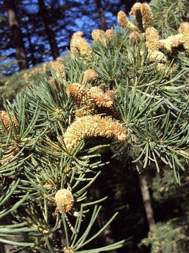
Male pollen on cedar tree 

Deodar is a member of conifers family, evergreen, with leaves modified into needles. Rosette arrangement of needles, distinguish it from the rest of the family members. It also presents a best example how they adapt themselves to the harsh climatic Himalayan conditions. The modification of leaves into needles minimizes the surface area to the sunlight, thus avoiding excessive transpiration. The thin mucilage on needles shields the frost in winters. Thick bark of the trunk and branches also protect it from harsh climatic conditions.


                                              Cedar sapling sprouting out from the seed


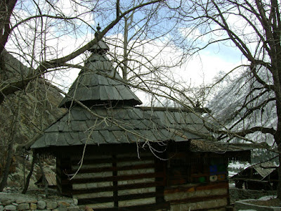
The typical Himalayan wooden architecture in Himachal is also due to Himalayan Cedar. The resin in the tree possesses a unique property of being anti-termite, devise it a perfect tree for wooden architecture. The elasticity and flexibility of the wood makes it suitable for Himalayan regions which are regarded as seismic-zones. Thus during earthquakes the entire wooden structure would shake and regain its original position instead of crumbling down or bending down as iron girders. This causes minimum loss to the wooden building.


Another reason for choosing Cedar as a suitable building material is due to the climatic conditions, Himalayas experience a very harsh weather conditions in winters and some higher regions here remain under snow for about 5-6 months. Cedar wood as other trees is a bad conductor of heat and electricity, thus trap the heat inside the room in winters irrespective of the cold weather outside.

Saturday, February 6, 2010

Famous peaks and early climbing in Himachal Pradesh.

The hidden Himalaya.

As this is my first post of year 2010, I would like to forward my heartiest best wishes for the year ahead. The highest peaks of Himachal Pradesh and some from Uttaranchal has been discussed here.

Jorkanden (6473 M)
The highest peak in the Kinner-Kailash range; one can admire it comfortably from a bungalow at Kalpa. Often mistaken called Kinner Kailash (which is a smaller holy pillar to north of it). It has been climbed by the I.T.B.P IN 1974 and by the IndianPara Regiment in 1978.

Rangrik Rang (6553 M)
The highest peak in southern Kinnaur rises on the Thrung valley and on to Racho glacier. To its north is the Baspa valley. Its first ascent was made by the Indo-British team (Chris Bonington – Harish Kapadia) in 1994. They climbed the north East Ridge from the col. The north face is the ultimate challenge on this peak. There are several high peaks in the valley.

Reo Purgyil (6816 M)
The highest peak in Himachal Pradesh. It rises to the north of Shikpi-La, from where the Satluj enters India and is formidable challenge justifying its name, abode of demon. The first ascent was made by I.T.B.P in 1971 but no details were available; this climb was always questioned. In 1991 four climbers from Delhi (Yousuf Zaheer) climbed to the top by the west ridge-wets shoulder. On the top they found an old bamboo stick, putting at rest any doubts about the 1971ascent!

Hansbeshan (5240 M)
One of the beautiful unclimbed peaks of the middle Himalaya. It rises above Nichar on the road to Kinnaur. It will be a good challenge and represents many peaks up to these heights in the area, totally free of any restrictions. The area has hard rock faces and easy approaches. A veritable for climbers, if height is not major consideration.

Swargarohini (6252 M)
The highest of a group of five, this peak forms a path to heaven, followed by Pandavas, Draupadi and their dog. It has been attempted from both the Ruinsara valley as well as from the Jamdar Bamak in the Har-ki-doon valley. Swaragohini II (6247 M) was first climbed in1974 by and Indo-Canadian team. In 1985 an Indian party made the second ascent and first of Swargarohini III (6209 M). In 1977 Indians climbed Swargarohini IV (5966 M). The first ascent of the main peak was made by the instructors of Nehru Institute of Mountaineering in 1990. They climbed a complicated route to the east col and followed the gentle ridge to the summit. Due to a dangerous cornice they stood about 5 M below the peak.


Bandarpunch west (6102 M)
Previously known as White Peak, this southwesterly neighbor of Kala Nag has a long approach of 18km over the Bandarpunch glacier to its summit. It was first climbed in 1984 by an Indian team (Haarish Kapadia) who followed the north East Ridge. The east face that defied Gibson and Tensing Norgay in 1950, remains unclimbed.


Shila (6132 M)
In 1860, a Khalasi of the survey of India climbed this remote peak. It remained as an altitude record for forty-seven years, as the height was computed to be 23,046 ft. however the modern survey has diminished it to 20,120ft (6,132 M).

Gyagar (6400 M)
A beautiful high peak between the Lingti and Chaksachan nalas in Spiti, it defeated an attempt in 1987. Its name means Indian. It is strategically located and can be seen promptly from Tibet. The first ascent for the peak was made in 1989 (Dhiren Pania) by an Indian team from Bombay.

Gaya (6794 M)
The highest peak in Himachal Pradesh remained unknown till the late 1980s. This stupendous rock monolith at the tri-junction of Spiti (Lingti valley), Laddakh (Rupshu) and Tibet (Pare-Chu) offers a long and difficult approach to the base of one of the finest rock-climbing challenges still left. After the early exploration of the routes in 1983 and 1987 (Harish Kapadia), the peak was being approached via Lingti valley when it was possible to cross the river gorge. The attempts by this route in 1996 and 1997 reached high on the mountain and climbed nearby summit. An army team in 1995 claimed an ascent which was disapproved in scrutiny. In 1997 a strong and huge team from SAARC countries attempted the peak from the north (Col H.S. Chauhan). They too misidentified the main peak. Thus Gaya remains unclimbed.

Ratang Tower (6170 M)
This peak rises on the Ratang-Gyundi divide in the western Spiti. It has been only climbed once, in 1956 by Peter Holmes and Rikzen Ladakhi. There are several other peaks on the same ridge and on this valley which awaits climbers.

Manirang (6593 M)
Straddling on the divide between Kinnaur and Spiti this towering peak has a brief history. In 1952 Dr. J.D.V Graaff, in 1994(Harish Kapadia) climbed it. A direct route also has been attempted on this peak in 1988 and 1996.

Parilungbi (6166 M)
A mountain in other country – such peaks were used as landmarks on the border; here between Spiti and Ladakh. They were also trade posts. On the summit of this peak stands a survey pole (Parang – la Station 1). It is situated at the head of Lingti valley – Yangzi Diwan pass, overlooking the Parang-La trade route. It was climbed in 1987 by an Indian team (Harish Kapadia).

Central Peak (6285 M)
The mountain rises at the northeast end of Bara Shigri, sandwiched between the jungles of peaks. It was climbed by two British women and two sherpas in 1961.they reached the saddle between Central peak and it southern neighbor, Lion (6,126m) and then climbed both peaks. Theses peaks have had repeated ascent thereafter.

Manimahesh Kailash (5,655 M)
Every range in the Himalaya has its own Kailash. This one in Chamba is the most formidable challenge by its southern approaches. It rises above the Manimahesh Lake and Chobu pass. the first ascent was made in 1968 by an Indo-Japanese team by the easier northern approach.

Papsura (6,451 M) and Dharmsura (6,446 M)
A prominent peak on the watershed dividing the Tos and the Brara Shigri glaciers in Lahaul, Papsura is the peak of evil. To its southeast is Dharmsura which is the peak of Good. Papsura was first climbed in 1976 by a British team which came over the Malana glacier, crossed the pass of the Animals and the Papsura glacier to climb the western couloir of the south face to the summit, despite an accident to the first summit team.
Several expeditions have confused Dharmsura with Papsura. Dharmsura (previously known as White Sail) was first climbed by a British expedition in 1941.

Gepang Goh (5870 M)
A fine, inviting peak above the road to Keylong, first climbed by Gen C. G. Bruce. It has a group of various summits and only a few of these have been climbed or attempted. One of the summits was climbed by Indian Army team in 1997.

Tuesday, September 8, 2009

Technical Climbing


Climbing peaks around Manali, Himachal Pradesh India.

Friendship Peak- 5289m

Location
Friendship peak is situated in Pir Panjal range with height of 5289m. Road head is Solang Nala which is main town in Solang Valley-15 km. from Manali.

Peak Type
Rock & Snow & Ice.
Knowledge Required
Knots, Ascending and Descending on Snow, Walking in a rope, Use of ice axe & Crampon.

Name of item and quantity required per person for climbing.
Climbing rope 1
Snow sack 2
Dead man or boy 1
Climbing helmet 1
Torch 1
Seat harness 1
Rope or tape sling 1
Gaiter 1
Crampons 1 pair
Mittens 1 pair
Pulley 1
Plain carrabineer 1 pair
Locking carabineer 3
Jumar 1
Ice tubular pitons 2
Rock pitons 3
Rain sheets 1
Climbing Shoes 1 Pair
Rucksack 1
Crampons 1Pair


Personal items

Wind proof suit 1

sun glasses 2

Monkey cap 1

Gloves 1 Pair

Nylon socks 2 Pair

Sun cream 1

Swiss knife 1

Mass tin 1

Dry fruits (cashew & almonds) 500 gm

Hat 1

Personal first aid box 1

Please note: All the items mentioned above are availabe on rental basis also.

Climb Itinerary

Like last year-again we are e booking climbing in Himalayas where you will be provided all infrastructures to climb this 17200 ft. peak. If you are having high altitude trekking experience- just contact us ASAP and get booked for climbing with us.

Duration: 11- 12 Days

Most frequent Climbing Plan:
Day1: Chandigarh/Delhi- Manali (1900 meters/6000ft)

Day2: A short trek around Manali

Day3: Manali –Dhundhi ( 2900mts, 10550ft) 15 km drive to Solang Nala, than after 7 km easy trek to Dhundhi, over night in alpine tent.
Climbing grade- easy.

Day4: Dhundhi – Bakarthach (12000ft, 3900mts- 6 km 3 hrs, through the land of shepherds)
Climbing grade- easy, moderate slopes.

Day 5:Bakerthatch- day for acclimatization/ techniques practice of ascending, descending or self arresting practice on snow, technique of cramponing.

Day 6: Bakarthach- camp 1 (14000ft 3900mts) 5 hrs climbing through slops, Glaciers moraines.
Climbing grade –easy, moderate.

Day 7: camp 1 – camp 2 - (16000ft, 5300mts- 6 hrs climbing.
Climbing grade slabs, glaciers

Day 8: Camp 2 / Summit attempt- (7 hrs climbing or descending on heard packed snow or glaciers.
Climbing grade- moderate, glaciers difficult.

Day9: Reserve for summit.

Day 10: Back to Dhundi.

Day 11: Back to Manali.

Day 12: Back to Delhi/ Chandigarh.

Experience required

You do not have to have any experience of climbing although exposure of high altitude trekking is necessary. Knowledge and use of climbing gear will enhance your enjoyment and comfort ability -although we will provide you resources and guidance to climb. Start jogging /running and work out for at least a month before you climb.

Mount Ladakhi / Chatidhar- 5500m,17900ft


Ladakhi Peak

Moderate level of peak which requires a little bit of climbing experience like use of mountaineering equipment and walking in snow and ice. This is certainly not for beginners. If you are first time climbing in Himalayas or climbing first time-choose Friendship peak.


Peak Type
Rock & Snow.

Name of item and quantity required per person for climbing would be same as mentioned above.

Most frequent Climbing Plan:
Day1: Chandigarh/Delhi- Manali (1900 meters, 6000ft)
Day2: A short trek around Manali.
Day3: Manali –Dhundhi (10550ft 3100mts) “15 km drive to Solang Nala, than after 7 km easy
trek to Dhundhi, over night in alpine tent.
Climbing grade- easy.
Day4: Dhundhi – Bakarthach (12000ft, 3600mts- 6 km 3 hrs, through the land of shepherds,)
Climbing grade- easy, moderate slopes.
Day 5:Bakerthatch- day for acclimatization/ techniques practice of ascending, descending or self arresting practice on snow, technique of cramponing.
Day 6: Bakarthach- Beas kund “saintly lay of sage Beas” (13000ft 3950mts) 3 hrs climbing through slops, Glaciers moraines.
Climbing grade- moderate, glaciers.
Day 7: Beas Kund / day reserve for acclimatization/ learn techniques of climbing, ascending, descending, self arresting practice on snow or cramponing.
Day 8: Beas kund – camp 1 (16500 ft 4900 mts Crossing Shitidhar col and establishing camp Incredible sight of Hanuman Tibba ,seven sisters peaks of Dhola Dhar range looks awesome.
Climbing grade- moderate or slabs.
Day 9: Camp1 / camp 2 -17500ft, 5225mts (camp on the top of the Raigarh glaciers
Climbing grade- moderate slabs (ice or hard packed snow)
Day 10 camp 2 / Summit Attempt/ Beas kund (18500ft, 5500mts)
Climbing grade- moderate, difficult (climbing on snow or rock)
Day 11: Back to Dhundi.
Day 12: Back to Solang Nala/Manali.
Day 13: Back to Chandigarh and on Day 15 you reach Delhi.

MAKING YOUR CLIMB MORE CONVENIENT
In case you encountered bad weather- we shall be providing you two spare days for climbing and you shall not be charged for these.

CLIMBING ARRANGEMENTS
We can arrange everything you need for climbing, you are required to bring only your 'climbing shoes'.

SHITIDHAR can be climbed with good pair of snow shoes and we will provide you porters, tented accommodation, local mountain guide, equipment along with vegetarian food.
Your stay in hotel is also inclusive in quote and there are no hidden charges as all taxes and relevant levies are also inclusive of quote.

Seven Sisters - 15000ft-16250ft
Seven Sisters

Road Head: Manali / Solang Nala

Height: 15000 ft to 16250ft.

Peak Type: Rock & Snow Knowledge Required: Ascending and Descending in Snow.

Climbing Plan

Takeover Point Delhi/ Manali

Day 1: Travel from Delhi/Chandigarh to Manali).

Day 2: A short trek around Manali, evening free to explore market.

Day 3: Trek to Dhundi- after break fast 15 km drive to Solang than start trek to Dhundhi (10550ft, 3100mts (6 km. walk)

Day 4: Dhundhi/ Bakarthach (1200ft, 3900mts) 3 hrs trek to Bakarthatch through the shepherd Land.

Day 5-6: Bakarthctch/ Attempt/ Baker thatch. The beautiful summit of Dholadhar” 16350ft

Day 7: Back to Solang Nala/Manali.

Day 8: Back to Delhi/Chandigarh.


Monday, August 17, 2009

Through the Indian Trans-Himalaya


Parang-La trek

27th July – 03rd August, 2009

The land is so barren and the passes are so high that only the best friends or fiercest enemies would want to visit us.

- Ladakhi proverb

The barren Himalayan land of Ladakh, with its inhospitable terrain has been a stimulant for adventure lovers all around the world. The trek from Spiti to Ladakh over Parang-La is a voyage into heaven; also it is a test of fitness to march over 5,578mt (18,300ft). The waters of Tso-Moriri changes colors as the day progress and the barren, snow capped mountains resemble it with an imagination of an artist. Walking over the high mountain passes and revolving the prayer wheels of the fascinating monasteries, words cannot describe its all about experience.

Last month, I also took a remarkable voyage through this awestruck and highest mountain system of the world. Though the trek was to start on 27th July 2009 but we reached there one day in advance from Shimla.

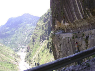
Shimla to Kibber village (4,205mt), the starting point of the trek, is 15- 18 hours of drive through the rough Himalayan roads. Due to some unwanted delays we could make till Tabo for the first day. Tabo wraps up a 1200 years old rich Tibetan Buddhists culture and tradition in expanded complex of monasteries. Continuing further, to Rangreek, a small village at the bank of river Spiti, we met rest of the five Dutch nationals who were the guests for the trek with us. Later on we drove up to Kibber for overnight stay.

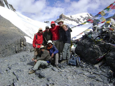
They all are members of a Dutch social organization, which adopts an area for five years. They organize medical camps in the villages around the area and distribute medicines to the public, they mainly emphasize for the welfare of the community especially children to these forgotten Land of northern India.

Day 01

The dawn broke behind the snow clad mountains and after breakfast the crew set ready for a week long march through some of the most stunning landscapes and highest passes on earth. I, along with my colleagues Kavi, Jawahar, the cook, and there were three other Horsemen and ten Horses with our five guests. From Kibber we descended into a deep gorge, Shilla Nullah, which pours the glacial deposits of Shilla peak. This is the highest peak in Himachal Pradesh.


Advancing gradually up, we came across small terrace farms loaded with green peas Dumle, a fertile patch of land with abundance of water for irrigation. The sound of the horse bells, walking uphill was in perfect harmony with the solitude of the place. Three hours of serious walk ended at a flat ground on the mountain ridge, 4,740mt, and this place hosted La-Darcha, a famous ancient trade fair held by Ladakh, Tibet and Spiti. Thus we were on the same trek which for centuries remained as a famous trade route.
Descending downhill to the other side soon we came to a flat meadow which concluded our first day walk. The camping ground framed the panorama of snowcapped mountain ranges enveloped with mist.
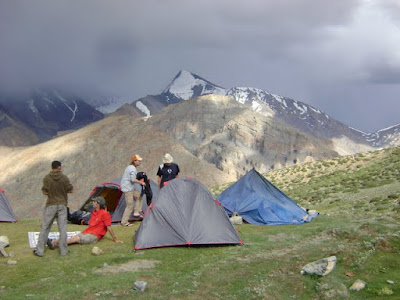


One of the guests was admiring the landscape with binoculars near his tent and he suddenly yelled that he located a herd of blue sheep that added the sites to be more beautiful. At dusk, the white snow on the mountains turned into golden and the atmosphere around was purely meditative.
From a distance one could senses the delicious aroma from the kitchen tent as our cook was busy to make a taste of the wilderness. The group came for the dinner in the kitchen tent as it was cozy and finally host at their respective tents.


Day 02

Early in the morning we prepared breakfast and lunch for the guests and at eight after breakfast Kavi along with the guests started for the base camp. We started after an hour down into a deep gorge with the river at the base.


This was Chor nullah (thieves gorge), named after the incidences of robbery which used to occur during the La-Darcha with the traders here. Following the river upstream for an hour, it opened into steep and a sharp uphill welcomed us. Kavi along with the team was visible from a long distance and very soon they disappeared high into the mountains.


Unfortunately for the second day of the trek also, we missed our lunch because it was being carried by Kavi who was now not visible behind the mountains. Jwahar (cook) and me had water, admired the landscape and continued towards the campsite. Now the trail become steeper and we could felt the thin air.


Suddenly behind the big rocks a dark face appeared, he was a Laddakhi (native of Ladakh), carrying nothing and slowly coming toward us. We said Julae (means hello) to him he smiled, after a brief conservation he revealed that he started two day before from Korzok (which will be ending point of our trek) along with his friend. And he said they had to reach at Kibber by evening. It was unbelievable; the trek which we are going to do in seven day these people could do it in three days.

Saying goodbye to him we continued and after an hour we were at the campsite. The group had also reached the base camp, Borojin (5,300mt) at the same time. As usual tents were pitched; tea and snacks were served to the group. The blue sky and the mountains above us were suddenly enveloped by thick clouds and it started snowing. The temperature dropped to zero. The entire team was briefed at dinner for the next day and soon everyone returned to the tents.

Day 03


This is going to be a big day, with some unknown reasons I was not able to sleep for the whole night. But still I was confident to make my day. After breakfast, at 730hrs along with the guests we (Kavi and me) left for the pass. But interestingly there were no signs of altitude sickness or fatigue to me; we all steadily advanced towards the pass. The Spanish group which has started an hour ahead of us was visible now. At wide chunk of glacier we all had rest for a while; two of the senior members were slow with the pace so we waited for them too.


The last stretch was almost a kilometer but now at an angle of eighty degrees, amount of oxygen in the air was very low. We all overtook the Spanish group, and in about another thirty minutes we all were at the pass.


In between Kavi assisted the senior lady doctor of our group with her daypack to the top of the pass. 5,570mt, from the mean sea level, at the top of pass there were celebrations, the team were overwhelming with the stunning panorama of the snow capped Himalayas.


I felt myself in a meditative mood; sat down quietly and gazed the mountains for a while, my eyes were moistened, and it was memorable for me and Kavi because we were together for the first time. I was carrying some prayer flags, I handed over to Kavi and with others he tied them as a mark to the holy mountains.


Mountains in ancient days were considered to be holy and often refer as god. There is an old saying that mountains are true divine structure that never moves. I wonder if my faith could move this mountain. For many ages these mountains were remained untouched and largely resembled the purest form of holiness. And some folk reveals that this is the place where sky and mountain meet.


In Buddhism, it is believed that tying the prayer flags on the mountain passes and the places with high winds, the prayers written on them will travel along the winds far.
Soon everybody got indulged in photography and then horses also reached. They also got warm welcome from all of us.
The view on the other side of the pass was equally stunning; it was a long, wide and seems endless. Semi-circular glaciers going deep down the valley. The snow has becoming loose by the heat of the blazing sun.


The next step from the pass was on to a glacier, which provides main source to a fascinating river called Parchu, it goes like a story as one describes about this River. More than a kilometer long glacier, down the valley is being fed by almost eight other glaciers on the adjoining sides. So, the interesting story of Parchu starts from Parang glacier in Ladakh, finds its way down and flow across 45kms long through Tibetan plateau. Again enters India at Sumdo check post, on the way to Tabo from Nako.

As the glacier melted, it was a bit tricky to walk on such surface; it made us to take each step very carefully. Otherwise, these crevasses can turn into frozen graveyards. We all proceeded down but just few meters below, the horses got struck in the deep snow. The horse-shoe injured their hind legs badly, the snow turned red as it bleeds and continue walking. This was serious concern; with the help of other horseman we decided to shift the loads till the end of glacier. Everyone felt pity for the poor animals.


The terrain turned into a loose rocky field as we descended into the valley. From either side of the valley, rattling of the rocks brought by the strong flow of the water left us confused. Leaving the group behind I rushed down to find a safe passage on the other side of the river, which now turned quiet fast with the glacial melting. A glacier made it easy for all of us to cross the river.

Within an hour of walk we all were on the plain by the bank of Parchu River where we decided to host the night. A hot cup of tea along with the some snacks refreshed each one of us. Soon, the sun hides behind the mountains and ended our third day.


Day 04


A glorious morning wakes us up to prepare for the day; we left the camp around eight in the morning and crossed the icy River of Parchu. Leaving the mountainous terrains behind, a lengthy flat ground shaped by Parchu welcomed us to march on its plains.


In the afternoon we had our packed lunch, and continued to descend into a funnel shaped valleys, the cliff was miraculously created by the movement of glaciers. As we walk up on its steep trail later in the evening the valley started to converge again.


On the way we met few groups, some ready to camp while others setting up their camps. Suddenly we saw a herd of yak escorted by a father and a son. The boy disclosed that they were going to sell these yaks in Kibber.

Little worried, I inquired Kavi about the campsite as it was going to be dark after an hour. “An hour” he replied, tiredness was clearly visible among our guests. Crossing a fast flowing glacial stream, we stuck because our trail was thrashed by the river.

There was no way except a steep climb which seemed endless as sky at that time. Surprisingly, I noticed a partly ruined passage not far away from where we were gazing. As the sand was difficult to hold the step, I led the team to follow my steps, and finally we all made it to the campsite.


At dinner, we discussed the day and everyone was delighted with their effort. Departure at seven was decided for the next morning.

Day 05

Everyone was curious to cross Parchu River in morning and it took four hours to reach Norbu Sumdo, where Parchu River makes a flat ground and thus easier to cross it.


Following the same trail further sixteen kilometers will leads us into Tibet but our destination was Changtang (Korzok). We all took off our shoes and changed to slippers, Kavi instructed the group about crossing of the river.


Though the water was less and the river was divided by small scattered islands that made us easy to cross.


From the other side we saw a pair of Kayang (wild Tibetan ass) as we were entering Changtang wildlife area.
Now we could see the green patches laid by Tso-moriri Lake but the lake was still in distance. We passed few settlements that have been deserted by nomadic tribe on the way. The day ended by the bank of Tso-Moriri Lake.


As the sun was setting behind the snow capped mountains, deep blue waters of the fresh lake sparkling into golden surface, Oh Lord! Teach us how to make thy creation more beautiful, words cannot describe such a stunning panorama. We camped near the lake for the night.

Day 06

A relaxed day beside Tso-Moriri and a short walk with option to decide the campsite was the itinerary for the day. The area of Changtang (Korzok) around Tso-Moriri Lake is a reserved wildlife sanctuary. The wildlife includes Kayang (Tibetan wild donkey), marmot, blue sheep, and ibex with some rare species of aquatic birds like Siberian crane, a migratory bird that travel thousands of mile and use this lake as their breeding grounds.


After a late breakfast we decided to move further, admiring the never ending blue waters of the lake as if an ocean locked between the Himalayan Mountains. We got enough chances to spot many beautiful birds including bold headed geese and black necked crane. Time fled fast like the shadows of clouds over the mountains and after five hours we decided to camp by the bank of the Tso-Moriri.


Later in the evening, winds were fast, noise of the waves broke the silence around. We decided an early dinner.

Day 07

The trek was going to end after five hours of a walk; this was the discussion at the breakfast. Few of our guests were getting sentimental about our memorable trip, as we continued walking by the lake, there were many travelers coming to see the lake that can never be imagined. Some are here to witness the Lake for a day while others to test their fitness over the Parang-La to reach Kibber.
Our trek ends as the lake ended and from a distance I could see a little mark of the road that shall lead me home. It was a delightful moment as we saw the terraces of the barley fields near a small village Changtang after a week long journey through the wilderness.
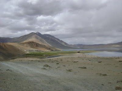
The place was so calm and people were so gracious, if I were sent as a soldier to demolish this mighty yet magnificent, powerful yet peaceful and uninterrupted settlement I shall chose to live with them as a warrior to protect them. There’s no enemy other than the gentle noise of the waves that opens your sense to admire them more and more. We pitched our tents on a flat ground near the village and stayed there overnight.

Day 08

Now the trek has e over, we packed our things in the cars, and left Changtang village and drive towards Leh over Tanglang-la (5,300mt).

It was quite a luxury to be in the car after a week long trek through meadows, gorges, cliff, passes, rivers and glaciers. We sang, shout, laughed and shared our joyous experience as we travel on the way home.
We reached Leh at 9 in the evening, we bid goodbye to our esteem guests to leave next morning for a non-stop 32hrs drive home to Shimla.

Saturday, July 18, 2009

Pare Chu - Story of a fascinating river in the western Himalaya.

Pare Chu - Story of a fascinating river in the western Himalaya.


The Himalayan germ, once caught, works inside like a relapsing fever, it is ever binding its time before breaking out again with increased virulence.
____ Marco Pallio.


The Pare Chu is a fascinating river that originates just outside the Spiti valley. The river runs northeast of Parang la to Norbu Sumdo in southeast Ladakh. It flows about 30km in Ladakh, turns southward towards Chumar and enters Tibetan territory at Lemarle. The river crosses another 85km until blocked by the Drongmar range, then re-enter Indian Territory south of Kaurik village. From here it converts another 12km before it joins the Spiti River near Sumdo. Strategically Pare Chu makes a complete circle east of the Spiti valley and provides all access routes to India from Tibet, via small tributaries along narrow valleys; the approach routes are difficult. It is not possible to ford the river at any time of the year as it is very fast flowing.

Tuesday, July 14, 2009

ECOLOGY AND ENVIRONMENT

ECOLOGY AND ENVIRONMENT

The two components of nature, viz. organisms and the environment are not only complex and dynamic, but also interdependent, mutually reactive and inter-related. Ecology deals with the various principles which govern such relationship between organisms and their environment.

The various communities of living organisms like plants and animals along with soil, air and water of that region form a self-sustaining or functional ambient of the living world. This functional unit or system made up of living and non-living components which is capable of independent existence is called an ecosystem.

All ecosystems are made up of two components i.e. abiotic components and biotic components. Abiotic components of an ecosystem includes the physical environment like soil, water and air along with the inorganic substances like carbon dioxide, nitrogen, oxygen, water and elements present in them. The physical factors or climatic factors like light, temperature, pressure and humidity are considered abiotic component of ecosystem.
The biotic component of ecosystem is a community of organisms (like plants, animals, microbes) which is made up of many different inter-dependent populations. The biotic community of ecosystem includes three types of organisms:
1) Producer organisms (or Autotrophs), which synthesize their own food. All the green plants are producers.
2) Consumer organisms (or Hetrotrophs), which are dependent on others of food. All the animals are consumers.
3) Decomposer organisms (or saprophytes), which consumes the dead remains of the other organisms. Certain bacteria, fungi and blue green algae are decomposers.
Thus, producers trap the solar energy and then provide the basic food or energy for all other life in ecosystem. The consumers (animals) derive their energy needs, directly or indirectly, from producers (plants). When the producers (plants) and consumers (animals) die, then the decomposer organisms act on their dead bodies to return the various elements back to the nutrient pool (soil, water, air), etc.
The natural ecological grouping of the plants and animals on the basis of climates are called “biomes”. The examples of biomes are: deserts, grasslands, tropical forests, temperate forests, etc. a biome is a very large ecosystem, having same type of climate, same type of plants and animals throughout. So, biomes are also termed as major ecosystems of the world.
A zone consisting of land, water and air, where life exists is called a “biosphere”. Biosphere includes all the living organisms of earth and all the life supporting regions of the earth.
Thus the biosphere consists of four parts: Lithosphere (land surface or soil); Hydrosphere (water bodies); Atmosphere (air); and living organisms (like animals and plants).
Food chains and food webs: the sequence of food from producers (green plants) to the ultimate consumer (human being) to transfer food energy unidirectionally is called food chain. A number of food chains are interconnected by organisms which occur in more than one food chain.
Biodiversity is the number of species of different organisms present in an area including all plants, animals and micro-organisms.
The aim of this aritcle is to create awareness for environment and to introspect that:
“Human activities are the root cause of global environment change. Unless we change many of our lifestyle patterns, the world will face unacceptable level of environment damage and human sufferings.”

Wednesday, July 8, 2009

Living with the Himalayan Masters.


His Holiness Dalai Lama

The state of Himachal Pradesh, in the north of India, shares its international borders with Tibet/China in the east. There are few scarcely populated pockets in the western Himalayas from where Buddhism prospered down in the whole Indian-sub-continent. Thought the deep roots of Buddhism dates back to 531 BC, when Siddhartha Gautama got enlightenment.

886 AD witnessed civil war in Tibet and forced Buddhist into exile in Laddakh, Lahaul-Spiti and Kinnaur. Since then, the deep valleys in the Himalayas, with the highest mountain system of the world echoed with ‘Om Mane Padme Hum’.

Spiti valley is dotted with monasteries like Tabo, enfolding 1013 glorious years of its existence. Dhankar, Lha-Lun, Tangyud (Komic), Kye, Kza, Kungri and Mud are the other noteworthy seats of Buddhist learning in the Himalayan region, where time seems to be mediating with the sacred mountains since ages.

This month from 9th July 2009 to 15th July 2009, His Holiness Dalai Lama will be on the tour of Spiti valley in Himachal Pradesh.

You all are cordially invited to be a part of this meditative meet in the Himal
You all are cordially invited.

Saturday, April 11, 2009

The noise of Cicada


The cicada is a large-bodied, dark-colored, flying insect with four long, transparent wings and large eyes. When at rest, the cicada holds the wings peaked over the body like a tent. Cicadas are not locusts (locusts are a type of grasshopper). Cicadas can damage twigs when eggs are laid in the twig (unlike locusts and grasshoppers who damage plants by defoliation - leaf eating).


Anatomy
Like all insects, the cicada has three body parts (the head, thorax and abdomen), two large, compound eyes, clear wings, and six jointed legs. They breathe through spiracles - small holes in the abdomen. The antennae are short and bristly. Adult cicadas range in size from 1 to 2 inches (2.5 - 5 cm) long.


Classification
Kingdom Animalia (animals), Class Insecta (insects), Order Homoptera (aphids, cicadas), Family Cicadidae (all cicadas), many Genera, including Genus Magicicada (long period, red-eyed cicadas - with a 13 or 17 year life cycle) and Genus Tibicen (dog-day cicada -- with a 2 to 5 year year life cycle). Some cicadas produce sounds louder than 100 dB! They modulate their noise by wiggling their abdomens toward and away from the tree that they are on.


Diet
Cicadas eat plant sap while in their long juvenile (nymph) stage.

Noise
Males make a shrill, buzzing call by vibrating two drum-like membranes (called tymbals) covering hollow chambers on the abdomen using muscles (females do not make this noise) - they usually do this while perching high up in trees. (This is unlike grasshoppers, who make noise by rubbing their back legs together.) Male cicadas call to attract females. The loudest insect in the world is the African cicada (Brevisana brevis); it regularly produces sounds at 106.7 dB at a distance of 50 cm (this is about as loud as a power saw).

Life cycle
The cicada has the longest life cycle of any insect, ranging from 2 to 17 years. A rice-shaped egg is laid in tender twigs and plant stems. The egg hatches into a nymph (the larval stage) and drops to the ground. The nymph burrows into the soil and crawls to a tree root (using its claw-like front legs). The nymph will eat the tree's sap. The nymph stage lasts up to 17 years in periodical cicadas; dog day cicadas have a shorter life cycle. There is no pupal stage. When the nymph is fully grown and the temperature is optimal, the nymph tunnels to the surface and goes through its final molt (shedding its hard outer skin) and emerges as a winged adult. When the wings dry and harden, the cicada flies in search of a mate. Unlike many other insects, all of the periodical cicadas in an area emerge at once.


Cicada Nymph
Almost all of life time Cicadas spend underground as nymphs. They borrow into the ground at depths of about 1 feet and up to 9 feet. The young Cicadas feed on roots of trees and grass. They usually suck juices and eat younger roots. Because they live underground and need to dig through it they developed strong front legs. When Cicadas are developed you can still see that front-legs are over developed in comparison with other legs. See picture on the top. When time comes for Cicadas to go from their underground tunnels to the surface they construct an exit tunnel and emerge for their skin shedding. Before Cicada become an adult and sheds its skin, it tries to find a plant where it attaches itself with its claws. Many times their shell will remain attached to a plant long after Cicadas hatched.

Cicada Skin
Cicada Nymph has skin has yellowish color and is very tough on the surface. This skin toughness is necessary for Cicada while its being developed underground. Since it has to borrow tunnels, it’s natural to have panzer like skin. Yellowish color may be attributed to dark conditions under the ground and as a result there is no need for skin mutation that matches surroundings like we’ll find it later when Cicada hatch and becomes an adult. When Cicada hatch, its Nymph skin splits in the middle allowing adult Cicada freely mutate into flying insect. Because of its toughness Cicada skin may be seen, long after its occupant left, attached to a tree branch of a grass.

Friday, April 3, 2009

International Symposium on Snow and Avalanches, 2009.


ISSA (International Symposium on Snow and Avalanches) 2009: Processes & effects of global climatic change

International Glaciological Society is organizing "International Symposium on Snow & Avalanches: Processes and Effects of Global Climate Change" from 06-10 April, 2009 at Snow & Avalanche Study Establishment (SASE), Manali, Himachal Pradesh (India).The symposium is aimed at bringing together researchers, practitioners, academia and industry on a common platform to discuss the recent advances and challenges in the field of snow science and avalanche mitigation. Leading experts from all over the globe are delivering talks on the relevant topics. Extensive deliberations by the participants both through poster and oral presentations are expected under various sessions. There will also be study tours and excursions to snowy forests of Pir Panjal range and other places of interest at the end of the symposium for the adventure and nature lovers.A parallel trade exhibition during the symposium proceedings shall be organized by industry partners to showcase the latest products and developments in the field of cold region science.

Theme
In recent times a change in the snowfall pattern has been observed all across the globe. Some experts attribute these changes to global climate changes. There is a need to carry out coordinated research to assess the possible implications of global climate change over local snowfall pattern, mountain weather and avalanche activity as very little attention has been paid to this aspect so far. This gains more importance in the wake of speculations that significant temperature and precipitation pattern variations may take place globally in near future. Hence the symposium focus will be on fundamental processes related to snow and avalanches, and on the effect of global climate change and possible adaption/mitigation measures

Topics
The suggested topics include:


1. Snow avalanches, including: Avalanche forecasting; Avalanche dynamics; Avalanche control and engineering


2. Snowpack, including:Snowpack properties and process modeling; Snowpack stability and spatial variability


3. Snow, including: Snow metamorphism, Snow hydrology; Snow and climate change: threat perception; Snow in the Himalayans; Snow, glacier mapping and global climate change


4.Observations and instrumentation, including:Observation networks in snowbound regions; Cold region instrumentation and measurement networks; Remote sensing applications of snow; glaciers and mountain hazards


5. Mountain meteorology6. Global connections between cryospheric regions

Friday, March 20, 2009

Journey to the Himalayas - 2009

Dear reader,
Greetings from Himalayas!
Year 2009 for adventure seekers has started, the calender will be soon updated but I have tried to capture some moments from the first Jeep Safari of the season(7th -12th march 2009).

As I mentioned this year is going to be amazing for adventure lovers along with trekking, Himalayas in this season is going to offer you Mountain Biking rallies over the Himalayan ranges & River Rafting form the source of the rivers.
Cheers,
Sanjay


Please be mild on my curves.
(The gateway to Kinnaur valley)


Baspa valley, where else to go now......!


An areal view of Chitkul village.


A slate roofed village house at Chitkul


An old temple in Chitkul village


A newly built monastery in Sangla village


Sunrise, Kinner Kailash range


Morning at Kalpa village


Kalpa also known for its beautiful temples


Kinner Kailash changes seven colors during the day.


An interior view of a Tibetan monastery